
Thank you for supporting this site ❤️
Make a donation
Make a donation
Kruševo topographic map
Click on the map to display elevation.
Thank you for supporting this site ❤️
Make a donation
Make a donation
About this map
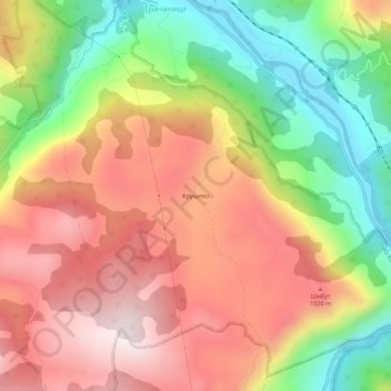
Name: Kruševo topographic map, elevation, terrain.
Average elevation: 822 m
Minimum elevation: 462 m
Maximum elevation: 1,143 m
Thank you for supporting this site ❤️
Make a donation
Make a donation
Other topographic maps
Click on a map to view its topography, its elevation and its terrain.
Бродарево
Serbien > Zentralserbien > Златиборски управни округ > Општина Пријепоље
Average elevation: 718 m