
Thank you for supporting this site ❤️
Make a donation
Make a donation
Olesa de Montserrat topographic map
Click on the map to display elevation.
Thank you for supporting this site ❤️
Make a donation
Make a donation
About this map
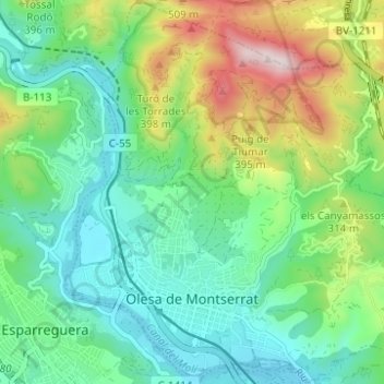
Name: Olesa de Montserrat topographic map, elevation, terrain.
Location: Olesa de Montserrat, Baix Llobregat, Barcelona, Catalonia, Spain (41.53269 1.87273 41.57900 1.93325)
Average elevation: 220 m
Minimum elevation: 64 m
Maximum elevation: 591 m
Thank you for supporting this site ❤️
Make a donation
Make a donation
Other topographic maps
Click on a map to view its topography, its elevation and its terrain.
Plaça de Mahatma Gandhi
Spain > Catalonia > Baix Llobregat > Esplugues de Llobregat
Average elevation: 74 m
Poble Nou
Spain > Catalonia > Baix Llobregat > Sant Vicenç dels Horts > Poble Nou
Average elevation: 62 m