
Kassel topographic map
Interactive map
Click on the map to display elevation.
About this map
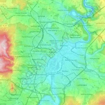
Name: Kassel topographic map, elevation, terrain.
Location: Kassel, Hesse, Germany (51.26038 9.35102 51.36940 9.57008)
Average elevation: 226 m
Minimum elevation: 125 m
Maximum elevation: 560 m
Other topographic maps
Click on a map to view its topography, its elevation and its terrain.
Bad Nauheim
Germany > Hesse > Bad Nauheim
Bad Nauheim, Wetteraukreis, Regierungsbezirk Darmstadt, Hesse, 61231, Germany
Average elevation: 175 m