
Thank you for supporting this site ❤️
Make a donation
Make a donation
Sungai Pinji topographic map
Click on the map to display elevation.
Thank you for supporting this site ❤️
Make a donation
Make a donation
About this map
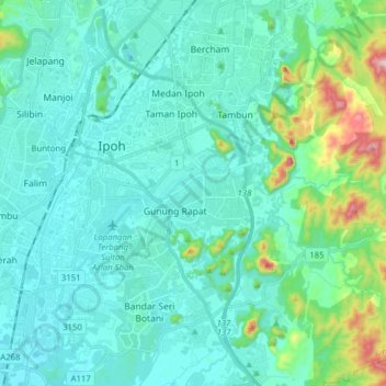
Name: Sungai Pinji topographic map, elevation, terrain.
Location: Sungai Pinji, Ipoh, Majlis Bandaraya Ipoh, Perak, Malaysia (4.50159 101.05479 4.65747 101.17281)
Average elevation: 101 m
Minimum elevation: 17 m
Maximum elevation: 555 m
Thank you for supporting this site ❤️
Make a donation
Make a donation
Other topographic maps
Click on a map to view its topography, its elevation and its terrain.