
Make a donation
Ramsau am Dachstein topographic map
Click on the map to display elevation.
Make a donation
Ramsau am Dachstein
Ramsau am Dachstein is situated between the Dachstein range of mountains in the north and the Enns valley in the south. While the Dachstein range contains peaks up to 2,995 m (9,826 ft) and the towns of the Enns valley, such as Schladming, lie at around 700 m (2,300 ft) above sea level, the Ramsau plateau is a comparatively level piece of land at an elevation of around 1,100 m (3,600 ft). Towards the north, some hills at the foot of the mountain range rise up to 1,700 m (5,600 ft). At approximately 75 km² (29 sq mi), the plateau is an exceptional geological feature in the rugged terrain of the Alps which is more usually characterized by high mountain ranges and narrow valleys.
Make a donation
About this map
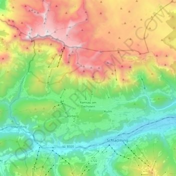
Name: Ramsau am Dachstein topographic map, elevation, terrain.
Average elevation: 1,526 m
Minimum elevation: 711 m
Maximum elevation: 2,897 m
Make a donation
Other topographic maps
Click on a map to view its topography, its elevation and its terrain.
Make a donation
Make a donation
Make a donation
Planneralm
Austria > Styria > Bezirk Liezen > Irdning-Donnersbachtal > Planneralm
Average elevation: 1,747 m
Donnersbachwald
Austria > Styria > Bezirk Liezen > Irdning-Donnersbachtal > Donnersbachwald
Average elevation: 1,337 m
Make a donation
Make a donation