
Make a donation
Weimar topographic map
Click on the map to display elevation.
Make a donation
Weimar
Weimar is situated within the valley of Ilm river, a tributary of Saale river on the southern border of the Thuringian Basin, a fertile agricultural area between the Harz mountains 70 km (43 mi) in the north and the Thuringian Forest 50 km (31 mi) in the southwest. The municipal terrain is hilly; the height of the city centre in Ilm valley is approximately 200 m of elevation. To the north, the terrain rises to Ettersberg, the city's backyard mountain, 482 m in height. The range of hills in the south of Weimar rises up to 370 m and is part of the Ilm Saale Plate Muschelkalk formation. The eastern, central and western parts of the municipal territory are in agricultural use, whereas the Ettersberg and some southern areas are wooded.
Make a donation
About this map
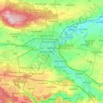
Name: Weimar topographic map, elevation, terrain.
Location: Weimar, Thuringia, Germany (50.91711 11.23491 51.03671 11.40196)
Average elevation: 299 m
Minimum elevation: 188 m
Maximum elevation: 481 m
Make a donation
Other topographic maps
Click on a map to view its topography, its elevation and its terrain.
Make a donation
Petrus (12. Apostel)
Germany > Thuringia > Landkreis Schmalkalden-Meiningen > Steinbach-Hallenberg
Average elevation: 704 m
Make a donation
Sondershausen
Germany > Thuringia > Kyffhäuserkreis > Sondershausen > Sondershausen
Average elevation: 292 m
Köditz
Germany > Thuringia > Landkreis Saalfeld-Rudolstadt > Saalfeld/Saale > Köditz
Average elevation: 277 m
Make a donation
Kerbe
Germany > Thuringia > Landkreis Schmalkalden-Meiningen > Steinbach-Hallenberg > Viernau
Average elevation: 447 m
Holland
Germany > Thuringia > Landkreis Nordhausen > Ellrich > Gudersleben > Holland
Average elevation: 271 m
Thamsbrück
Germany > Thuringia > Unstrut-Hainich-Kreis > Bad Langensalza
Thamsbrück is located in the west of the Thuringian Basin about 4 kilometres (2.5 mi) north of Bad Langensalza at an altitude of 175 metres (574 ft) above NHN. The surrounding area is agricultural. On the southern and western edge of the village, the Unstrut, with two river courses, flows eastwards to the…
Average elevation: 189 m
Make a donation