
Thank you for supporting this site ❤️
Make a donation
Make a donation
Arenas de Cabrales topographic map
Click on the map to display elevation.
Thank you for supporting this site ❤️
Make a donation
Make a donation
About this map
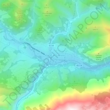
Name: Arenas de Cabrales topographic map, elevation, terrain.
Location: Arenas de Cabrales, Cabrales, Asturias, 33555, Spain (43.28338 -4.83471 43.32338 -4.79471)
Average elevation: 374 m
Minimum elevation: 121 m
Maximum elevation: 1,103 m
Thank you for supporting this site ❤️
Make a donation
Make a donation
Other topographic maps
Click on a map to view its topography, its elevation and its terrain.
Thank you for supporting this site ❤️
Make a donation
Make a donation