
Thank you for supporting this site ❤️
Make a donation
Make a donation
Damiș topographic map
Click on the map to display elevation.
Thank you for supporting this site ❤️
Make a donation
Make a donation
About this map
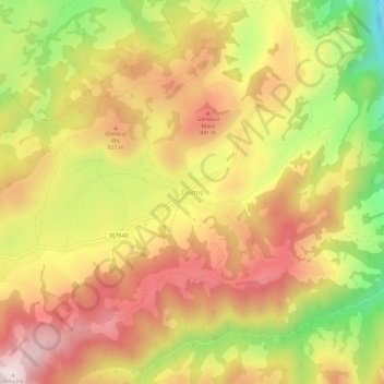
Name: Damiș topographic map, elevation, terrain.
Location: Damiș, Bratca, Bihor, 417082, Romania (46.84933 22.53651 46.88933 22.57651)
Average elevation: 721 m
Minimum elevation: 423 m
Maximum elevation: 945 m
Thank you for supporting this site ❤️
Make a donation
Make a donation
Other topographic maps
Click on a map to view its topography, its elevation and its terrain.
Thank you for supporting this site ❤️
Make a donation
Make a donation
Thank you for supporting this site ❤️
Make a donation
Make a donation
Salonta
Salonta has a continental humid climate, with warm to hot summers and cold to very cold winters, but relatively little snow. The average annual precipitation is 578 mm3 (0.0353 cu in). The average January temperature is −2.4 °C (27.7 °F) and in July it is 20.7 °C (69.3 °F) (averages for low and high). It…
Average elevation: 97 m
Thank you for supporting this site ❤️
Make a donation
Make a donation
Thank you for supporting this site ❤️
Make a donation
Make a donation
Thank you for supporting this site ❤️
Make a donation
Make a donation
Thank you for supporting this site ❤️
Make a donation
Make a donation
Thank you for supporting this site ❤️
Make a donation
Make a donation
Thank you for supporting this site ❤️
Make a donation
Make a donation
Thank you for supporting this site ❤️
Make a donation
Make a donation
Thank you for supporting this site ❤️
Make a donation
Make a donation