
Make a donation
Vancouver topographic map
Click on the map to display elevation.
Make a donation
Vancouver
Vancouver, British Columbia, is situated on the Burrard Peninsula, bordered by Burrard Inlet to the north and the Fraser River to the south. The city's topography is a blend of flat and hilly terrains, with elevations ranging from sea level to approximately 152 meters (500 feet) above sea level. The North Shore Mountains, including prominent peaks like Grouse Mountain and Mount Seymour, rise sharply to the north, providing a dramatic backdrop and influencing local weather patterns. These mountains are part of the larger Coast Mountain range and are characterized by rugged terrain with steep slopes and dense forests. To the west, Vancouver faces the Strait of Georgia, with Vancouver Island lying further offshore, offering a mix of coastal lowlands and rolling hills. This diverse terrain contributes to the city's scenic beauty and offers numerous recreational opportunities, from urban parks like Stanley Park to mountainous areas ideal for hiking and skiing.
Make a donation
About this map
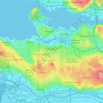
Name: Vancouver topographic map, elevation, terrain.
Average elevation: 34 m
Minimum elevation: -4 m
Maximum elevation: 156 m
Make a donation