
Thank you for supporting this site ❤️
Make a donation
Make a donation
Schnaittach topographic map
Click on the map to display elevation.
Thank you for supporting this site ❤️
Make a donation
Make a donation
About this map
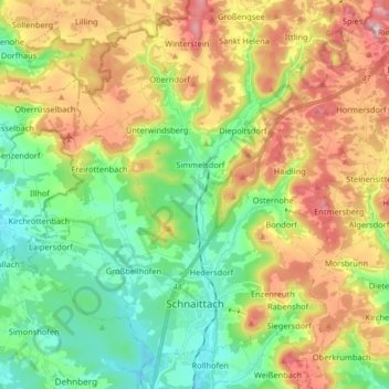
Name: Schnaittach topographic map, elevation, terrain.
Location: Schnaittach, Nürnberger Land, Bavaria, 91220, Germany (49.54453 11.26313 49.63366 11.42644)
Average elevation: 451 m
Minimum elevation: 331 m
Maximum elevation: 635 m
Thank you for supporting this site ❤️
Make a donation
Make a donation
Other topographic maps
Click on a map to view its topography, its elevation and its terrain.
Pegnitz
Germany > Bavaria > Nürnberger Land > Hersbruck > Weiher
The Pegnitz has its source in the town of the same name at an altitude of 425 m (1,394 ft) and meets the Rednitz at 283 m (928 ft) in Fürth to form the Regnitz river. Shortly after the source, the Pegnitz unites with the 15 km (9.3 mi) long Fichtenohe while keeping the name of the shorter tributary. Some…
Average elevation: 357 m