
Thank you for supporting this site ❤️
Make a donation
Make a donation
Rørvik topographic map
Click on the map to display elevation.
Thank you for supporting this site ❤️
Make a donation
Make a donation
About this map
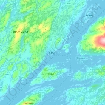
Name: Rørvik topographic map, elevation, terrain.
Location: Rørvik, Nærøysund, Trøndelag, 7900, Norway (64.82157 11.19791 64.90157 11.27791)
Average elevation: 31 m
Minimum elevation: -3 m
Maximum elevation: 288 m
Thank you for supporting this site ❤️
Make a donation
Make a donation
Other topographic maps
Click on a map to view its topography, its elevation and its terrain.
Thank you for supporting this site ❤️
Make a donation
Make a donation