
Thank you for supporting this site ❤️
Make a donation
Make a donation
Oberstdorf topographic map
Click on the map to display elevation.
Thank you for supporting this site ❤️
Make a donation
Make a donation
About this map
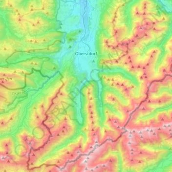
Name: Oberstdorf topographic map, elevation, terrain.
Location: Oberstdorf, Landkreis Oberallgäu, Bavaria, 87561, Germany (47.27011 10.08294 47.47158 10.38930)
Average elevation: 1,490 m
Minimum elevation: 751 m
Maximum elevation: 2,623 m
Thank you for supporting this site ❤️
Make a donation
Make a donation
Other topographic maps
Click on a map to view its topography, its elevation and its terrain.
Holdenried
Germany > Bavaria > Landkreis Oberallgäu > Wiggensbach > Wiggensbach
Average elevation: 904 m
Thank you for supporting this site ❤️
Make a donation
Make a donation
Thank you for supporting this site ❤️
Make a donation
Make a donation
Thank you for supporting this site ❤️
Make a donation
Make a donation