
Thank you for supporting this site ❤️
Make a donation
Make a donation
Værum topographic map
Click on the map to display elevation.
Thank you for supporting this site ❤️
Make a donation
Make a donation
About this map
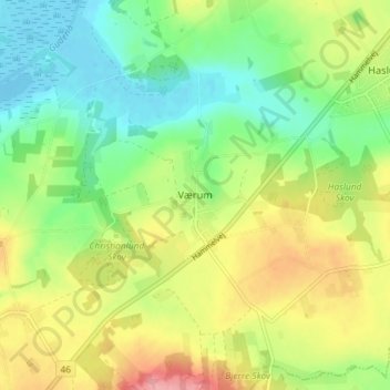
Name: Værum topographic map, elevation, terrain.
Location: Værum, Randers Municipality, Central Denmark Region, Denmark (56.38612 9.96986 56.42612 10.00986)
Average elevation: 42 m
Minimum elevation: -4 m
Maximum elevation: 104 m
Thank you for supporting this site ❤️
Make a donation
Make a donation
Other topographic maps
Click on a map to view its topography, its elevation and its terrain.
Thank you for supporting this site ❤️
Make a donation
Make a donation
Thank you for supporting this site ❤️
Make a donation
Make a donation
Thank you for supporting this site ❤️
Make a donation
Make a donation
Anholt
Denmark > Central Denmark Region
The western fifth of Anholt consists of hilly moraine country, while the eastern four-fifths of the island consist of mostly flat raised seabed with some low hills, former wind-blown sand dunes. Only the western moraine hills are inhabited. The eastern part, called "Ørkenen" (The Desert) is treeless; the…
Average elevation: 2 m
Thank you for supporting this site ❤️
Make a donation
Make a donation
Thank you for supporting this site ❤️
Make a donation
Make a donation