
Make a donation
Sunshine Coast Regional topographic map
Click on the map to display elevation.
Make a donation
Sunshine Coast Regional
The Sunshine Coast Regional area in Queensland, Australia, features a diverse topography that ranges from coastal plains to rugged hinterlands. Along the coastline, the terrain is predominantly flat, with average elevations around 20 meters (66 feet) above sea level. Inland, the landscape transitions to rolling hills and prominent mountain ranges, such as the Blackall Range, which includes peaks like Howells Knob rising to 561 meters (1,841 meters). The region also encompasses the distinctive Glass House Mountains, a series of volcanic plugs formed millions of years ago, with Mount Beerwah being the highest at 556 meters (1,824 meters). This varied terrain contributes to the Sunshine Coast's rich natural beauty, offering lush rainforests, scenic waterfalls, and panoramic vistas.
Make a donation
About this map
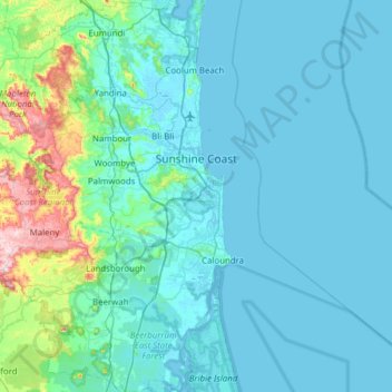
Name: Sunshine Coast Regional topographic map, elevation, terrain.
Location: Sunshine Coast Regional, Queensland, Australia (-26.98479 152.55111 -26.43106 153.15080)
Average elevation: 56 m
Minimum elevation: -2 m
Maximum elevation: 542 m
Make a donation
Other topographic maps
Click on a map to view its topography, its elevation and its terrain.