
Thank you for supporting this site ❤️
Make a donation
Make a donation
Splügen Pass topographic map
Click on the map to display elevation.
Thank you for supporting this site ❤️
Make a donation
Make a donation
About this map
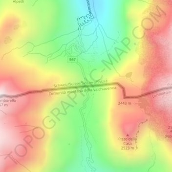
Name: Splügen Pass topographic map, elevation, terrain.
Location: Splügen Pass, Rheinwald, Viamala, Grisons, 7435, Switzerland (46.50555 9.33029 46.50565 9.33039)
Average elevation: 2,243 m
Minimum elevation: 1,808 m
Maximum elevation: 2,648 m
Thank you for supporting this site ❤️
Make a donation
Make a donation
Other topographic maps
Click on a map to view its topography, its elevation and its terrain.