
Thank you for supporting this site ❤️
Make a donation
Make a donation
East Flanders topographic map
Click on the map to display elevation.
Thank you for supporting this site ❤️
Make a donation
Make a donation
About this map
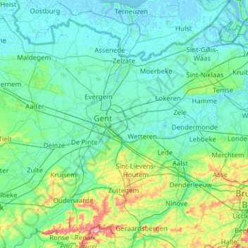
Name: East Flanders topographic map, elevation, terrain.
Location: East Flanders, Belgium (50.72101 3.33131 51.35397 4.33013)
Average elevation: 19 m
Minimum elevation: -4 m
Maximum elevation: 158 m
Thank you for supporting this site ❤️
Make a donation
Make a donation
Other topographic maps
Click on a map to view its topography, its elevation and its terrain.