
Make a donation
Cary topographic map
Click on the map to display elevation.
Make a donation
Cary
Cary is seated on the boundary between the Durham Basin with its softer sedimentary rocks and the piedmont with its harder metamorphic rocks; both geologic provinces have igneous rock intrusions. The landscape is typically gentle to moderate sloping hills separated by narrow V-shaped valleys, but there are areas with steeper slopes and broader, U-shaped valleys in western Cary, roughly along NC 55 near the Research Triangle Park and north of Green Hope School Road. Cary's average elevation is 495 ft (151 m).
Make a donation
About this map
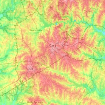
Name: Cary topographic map, elevation, terrain.
Location: Cary, Wake County, North Carolina, United States (35.64438 -78.95380 35.89688 -78.72946)
Average elevation: 111 m
Minimum elevation: 60 m
Maximum elevation: 160 m
Make a donation
Other topographic maps
Click on a map to view its topography, its elevation and its terrain.
Lake Raleigh
United States > North Carolina > Wake County > Raleigh > Isle Forest
Average elevation: 104 m
Make a donation
Prestonwood Soccer Complex
United States > North Carolina > Wake County > Cary
Average elevation: 111 m
Lake Johnson
United States > North Carolina > Wake County > Raleigh > Orchards
Average elevation: 121 m
Make a donation
Make a donation
Make a donation