
Thank you for supporting this site ❤️
Make a donation
Make a donation
El Salto topographic map
Click on the map to display elevation.
Thank you for supporting this site ❤️
Make a donation
Make a donation
About this map
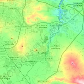
Name: El Salto topographic map, elevation, terrain.
Location: El Salto, Jalisco, Mexico (20.49312 -103.33343 20.58516 -103.16883)
Average elevation: 1,553 m
Minimum elevation: 1,439 m
Maximum elevation: 1,753 m
Thank you for supporting this site ❤️
Make a donation
Make a donation
Other topographic maps
Click on a map to view its topography, its elevation and its terrain.
Tequila
Tequila is one of the 124 municipalities of Jalisco, located just west of the center of the state. Its territory extends for 1689.11km2, with elevations that vary between 700 and 2,900 meters above sea level. The municipality borders with the main metropolitan region of Guadalajara to the east (Zapopan), and…
Average elevation: 1,267 m
Thank you for supporting this site ❤️
Make a donation
Make a donation
San Cristóbal Zapotitlán
Mexico > Jalisco > Jocotepec > San Cristóbal Zapotitlán
Average elevation: 1,552 m