
Thank you for supporting this site ❤️
Make a donation
Make a donation
Las Tejerías topographic map
Click on the map to display elevation.
Thank you for supporting this site ❤️
Make a donation
Make a donation
About this map
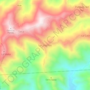
Name: Las Tejerías topographic map, elevation, terrain.
Average elevation: 775 m
Minimum elevation: 433 m
Maximum elevation: 1,080 m
Thank you for supporting this site ❤️
Make a donation
Make a donation
Other topographic maps
Click on a map to view its topography, its elevation and its terrain.
Parroquia Los Teques
Venezuela > Estado Miranda > Municipio Guaicaipuro
Los Teques es la ciudad capital del Estado Miranda y del Municipio Guaicaipuro. Está ubicada en la Región Capital en el centro-norte de Venezuela. Específicamente, al SO de Caracas, a 10°21′00″ de latitud N y a 67°02′30″ de longitud O de Greenwich, a una altitud de 1169 m sobre el nivel del mar.…
Average elevation: 1,029 m