
Thank you for supporting this site ❤️
Make a donation
Make a donation
Ringvål topographic map
Click on the map to display elevation.
Thank you for supporting this site ❤️
Make a donation
Make a donation
About this map
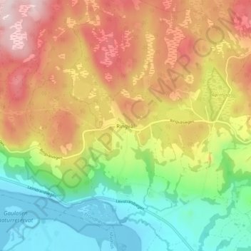
Name: Ringvål topographic map, elevation, terrain.
Location: Ringvål, Trondheim, Trøndelag, Norge (63.33562 10.23950 63.37562 10.27950)
Average elevation: 154 m
Minimum elevation: -3 m
Maximum elevation: 332 m
Thank you for supporting this site ❤️
Make a donation
Make a donation
Other topographic maps
Click on a map to view its topography, its elevation and its terrain.