
Make a donation
Zacapa topographic map
Click on the map to display elevation.
Make a donation
About this map
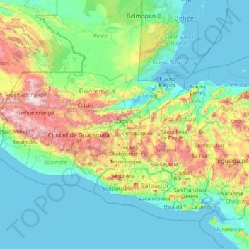
Name: Zacapa topographic map, elevation, terrain.
Location: Zacapa, Guatemala (12.36616 -92.11803 17.56616 -86.91803)
Average elevation: 465 m
Minimum elevation: -1 m
Maximum elevation: 3,808 m
Make a donation
Other topographic maps
Click on a map to view its topography, its elevation and its terrain.
Guatemala City
Guatemala > Guatemala Department
As it is in the tropics, Guatemala City has a tropical savannah climate (Köppen Aw) bordering on a more temperate humid subtropical climate (Cwa/Cwb) due to its relatively high altitude. Guatemala City is generally very warm, almost springlike, throughout the year.
Average elevation: 1,531 m
Make a donation
Guatemala City
Guatemala > Guatemala Department
Despite its location in the tropics, Guatemala City has a monsoon humid subtropical climate (Köppen Cwa) due to its relatively high altitude which moderate the average temperatures. Guatemala City is generally very warm, almost springlike, throughout the course of the year.
Average elevation: 1,531 m
Make a donation
Reserva Forestal Protectora de Manantiales Cordillera Alux
Guatemala > Sacatepéquez > San Pedro Sacatepéquez > Santiago Sacatepéquez
Average elevation: 1,953 m
Make a donation
San Antonio Suchitepéquez
San Antonio Suchitepéquez (Spanish pronunciation: [san anˈtonjo sutʃiteˈpekes]) is a town, with a population of 13,666 (2018 census), and a municipality in the Suchitepéquez department of Guatemala. The municipality is located at an elevation of 300 metres to 500 metres above sea level. It has a…
Average elevation: 327 m
Huitán
Huitán (Spanish pronunciation: [wiˈtan]) is a municipality in the Quetzaltenango department of Guatemala, situated on 16 km2 at 2600 m altitude, North-West from Quetzaltenango.
Average elevation: 2,667 m
Make a donation
San Marcos
The climate varies widely within the department, due to the dramatic differences in altitude, with the north possessing a cold Guatemalan Highlands climate and the south having a temperate or hot climate, depending on the specific altitude.
Average elevation: 1,345 m
Municipio de Quetzaltenango
Quetzaltenango (Spanish pronunciation: [keˌtsal.teˈnaŋ.ɡo], also known by its Maya name Xelajú [ʃelaˈχu] or Xela [ˈʃela]) is a municipality and namesake department in western Guatemala. The city is located in a mountain valley at an elevation of 2,330 meters (7,640 feet) above sea level at its lowest…
Average elevation: 2,489 m
Make a donation
Bosque San Antionio
Guatemala > Chimaltenango > San Juan Comalapa > San Juan Comalapa
Average elevation: 2,125 m
Make a donation
Make a donation
Make a donation
Make a donation
Make a donation
Make a donation
Guatemala City
Guatemala > Guatemala Department
Despite its location in the tropics, Guatemala City has a monsoon humid subtropical climate (Köppen Cwa) due to its relatively high altitude which moderate the average temperatures. Guatemala City is generally very warm, almost springlike, throughout the course of the year.
Average elevation: 1,531 m
Make a donation
Make a donation
Panajachel
Panajachel (Spanish pronunciation: [panaxaˈtʃel], Pana) is a town in the southwestern Guatemalan Highlands, less than 140 kilometres (90 mi) from Guatemala City, in the department of Sololá. It serves as the administrative centre for the surrounding municipality of the same name. The elevation is 1,597…
Average elevation: 1,776 m
Make a donation
Guatemala City
Guatemala > Guatemala Department
Despite its location in the tropics, Guatemala City's has a tropical savanna climate (Köppen Aw) bordering humid subtropical climate (Cwa), relatively high altitude moderates average temperatures. Guatemala City is generally very warm, almost springlike, throughout the course of the year. It occasionally gets…
Average elevation: 1,538 m
Make a donation
Make a donation
Make a donation
Make a donation
Make a donation
Panajachel
Panajachel (Spanish pronunciation: [panaxaˈtʃel], Pana) is a town in the southwestern Guatemalan Highlands, less than 140 kilometres (90 mi) from Guatemala City, in the department of Sololá. It serves as the administrative centre for the surrounding municipality of the same name. The elevation is 1,597…
Average elevation: 1,776 m
Make a donation
Make a donation
Municipio de Quetzaltenango
Quetzaltenango (Spanish pronunciation: [ketsalteˈnaŋɡo], also known by its Maya name Xelajú [ʃelaˈχu] or Xela [ˈʃela]) is both the seat of the namesake Department and municipality, in Guatemala. The city is located in a mountain valley at an elevation of 2,330 meters (7,640 feet) above sea level at…
Average elevation: 2,489 m
Make a donation
Bosque San Antionio
Guatemala > Chimaltenango > San Juan Comalapa > San Juan Comalapa
Average elevation: 2,125 m
Make a donation
Tikal
The city has been completely mapped and covered an area greater than 16 square kilometers (6.2 sq mi) that included about 3,000 structures. The topography of the site consists of a series of parallel limestone ridges rising above swampy lowlands. The major architecture of the site is clustered upon areas of…
Average elevation: 261 m
Make a donation
Make a donation