
Meknès topographic map
Interactive map
Click on the map to display elevation.
About this map
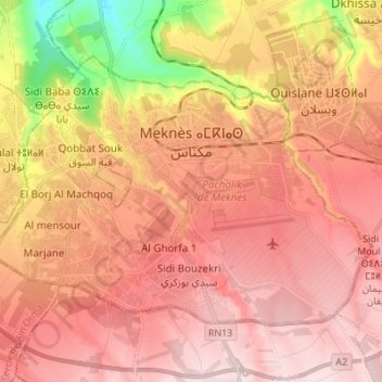
Name: Meknès topographic map, elevation, terrain.
Average elevation: 532 m
Minimum elevation: 311 m
Maximum elevation: 652 m
Die Stadt liegt in einer Höhe von etwa 520 m in einer fruchtbaren Ebene zwischen dem Zerhoun-Massiv im Norden und dem Mittleren Atlas im Süden.[4] Die Stadt Fès ist etwa 65 km (Fahrtstrecke) in nordöstlicher Richtung entfernt, die marokkanische Hauptstadt Rabat befindet sich gut 150 km westlich. Mitten durch die Stadt verläuft das Wadi Bou Fekrane. Das Klima in Meknès ist für marokkanische Verhältnisse gemäßigt; Regen (ca. 575 mm/Jahr) fällt nahezu ausschließlich im Winterhalbjahr.[5]