
Senillé topographic map
Interactive map
Click on the map to display elevation.
About this map
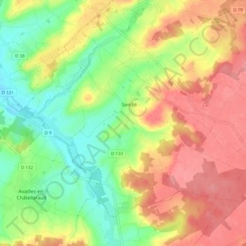
Name: Senillé topographic map, elevation, terrain.
Average elevation: 102 m
Minimum elevation: 55 m
Maximum elevation: 149 m
Other topographic maps
Click on a map to view its topography, its elevation and its terrain.
Les Essarts
France > Nouvelle-Aquitaine > Vienne > Senillé-Saint-Sauveur
Les Essarts, Saint-Sauveur, Senillé-Saint-Sauveur, Châtellerault, Vienne, Nouvelle-Aquitaine, France métropolitaine, 86100, France
Average elevation: 135 m