
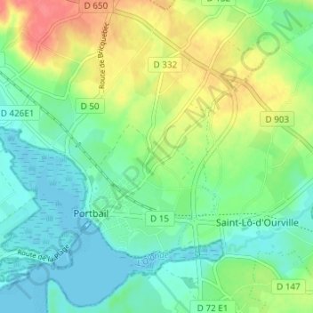
Saint-Marc topographic map
Interactive map
Click on the map to display elevation.
About this map
Name: Saint-Marc topographic map, elevation, terrain.
Average elevation: 20 m
Minimum elevation: -1 m
Maximum elevation: 56 m
Other topographic maps
Click on a map to view its topography, its elevation and its terrain.
Village du Havre
France > Normandie > Manche > Port-Bail-sur-Mer > Portbail
Village du Havre, Portbail, Port-Bail-sur-Mer, Cherbourg, Manche, Normandie, France métropolitaine, 50580, France
Average elevation: 15 m
Les Acacias
France > Normandie > Manche > Port-Bail-sur-Mer > Portbail
Les Acacias, Portbail, Port-Bail-sur-Mer, Cherbourg, Manche, Normandie, France métropolitaine, 50580, France
Average elevation: 6 m
Les Forges
France > Normandie > Manche > Port-Bail-sur-Mer > Portbail
Les Forges, Portbail, Port-Bail-sur-Mer, Cherbourg, Manche, Normandie, France métropolitaine, 50580, France
Average elevation: 18 m
La Hieullerie
France > Normandie > Manche > Port-Bail-sur-Mer > Portbail
La Hieullerie, Portbail, Port-Bail-sur-Mer, Cherbourg, Manche, Normandie, France métropolitaine, 50580, France
Average elevation: 16 m