
Jihomoravský kraj topographic map
Interactive map
Click on the map to display elevation.
About this map
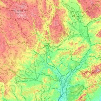
Name: Jihomoravský kraj topographic map, elevation, terrain.
Location: Jihomoravský kraj, Southeast, Czechia (48.61654 15.54242 49.63326 17.64694)
Average elevation: 354 m
Minimum elevation: 141 m
Maximum elevation: 953 m
With an area of 7,187.8 km2 the South Moravian Region is the fourth largest region of the Czech Republic. The highest point of the region is located in the eastern part on Durda mountain (842 m). The point with the lowest elevation (150 m) is situated in Břeclav District at the meeting of the rivers Morava and Dyje.
Other topographic maps
Click on a map to view its topography, its elevation and its terrain.
Brno
Czechia > Southeast > Jihomoravský kraj
Brno, okres Brno-město, Jihomoravský kraj, Southeast, Czechia
Average elevation: 296 m