
Ganges topographic map
Interactive map
Click on the map to display elevation.
About this map
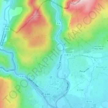
Name: Ganges topographic map, elevation, terrain.
Average elevation: 261 m
Minimum elevation: 139 m
Maximum elevation: 547 m
The main stream of the river Ganges begins at the confluence of the Bhagirathi and Alaknanda rivers in the town of Devprayag in the Garhwal division of the Indian state of Uttarakhand. The Bhagirathi is considered to be the source in Hindu culture and mythology, although the Alaknanda is longer, and, therefore, hydrologically the source stream. The headwaters of the Alakananda are formed by snowmelt from peaks such as Nanda Devi, Trisul, and Kamet. The Bhagirathi rises at the foot of Gangotri Glacier, at Gomukh, at an elevation of 3,892 m (12,769 ft), being mythologically referred to as, residing in the matted locks of Shiva, symbolically Tapovan, being a meadow of ethereal beauty at the feet of Mount Shivling, just 5 km (3.1 mi) away.