
Trabzon topographic map
Interactive map
Click on the map to display elevation.
About this map
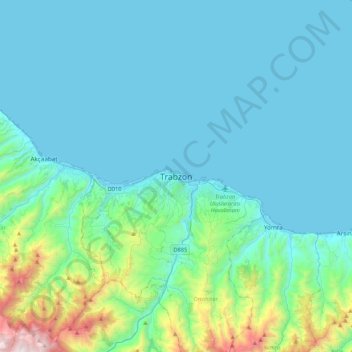
Name: Trabzon topographic map, elevation, terrain.
Location: Trabzon, Ortahisar, Trabzon, Black Sea Region, 61110, Turkey (40.84546 39.57015 41.16546 39.89015)
Average elevation: 241 m
Minimum elevation: 0 m
Maximum elevation: 1,863 m
Trabzon has a climate typical of the Black Sea region with plentiful precipitation. Under the Köppen climate classification, it has a humid subtropical climate (Köppen: Cfa) Summers are warm and humid, and the average maximum temperature is around 26.7 °C (80 °F) in August. Winters are cool and damp, and the lowest average minimum temperature is around 5 °C (41 °F) in January. Trabzon's summers are warmer than oceanic classifications, but the narrow fluctuations in temperature render a significant influence from the sea. As with other major cities on the Black Sea coast of Turkey, Trabzon is situated right on the waterfront, thus allowing for the additional 1–2 degrees Celsius enough to surpass the threshold to be classified as subtropical. In comparison, only 1 or 2 percent of the province is classified as subtropical, the majority being oceanic (Köppen: Cfb) followed by humid continental climate (Köppen: Dfb), due to the immediate elevation increase starting from the coast, a typical characteristic of the Black Sea coast of Turkey. Trabzon's weather station also sees tendencies of a Mediterranean climate (Köppen: Csa), but with only one month below 40 mm rainfall in summer it just fails to qualify.