
Thank you for supporting this site ❤️
Make a donation
Make a donation
Beauceville topographic map
Click on the map to display elevation.
Thank you for supporting this site ❤️
Make a donation
Make a donation
About this map
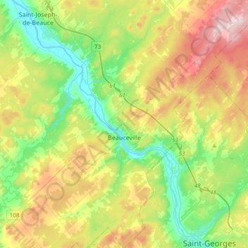
Name: Beauceville topographic map, elevation, terrain.
Average elevation: 285 m
Minimum elevation: 139 m
Maximum elevation: 528 m
Thank you for supporting this site ❤️
Make a donation
Make a donation
Other topographic maps
Click on a map to view its topography, its elevation and its terrain.
Thank you for supporting this site ❤️
Make a donation
Make a donation
Ruisseau Saints-Anges
Canada > Québec > Beauce-Centre > Saint-Joseph-de-Beauce
Average elevation: 270 m