
Al Jubayl Governorate topographic map
Interactive map
Click on the map to display elevation.
About this map
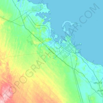
Name: Al Jubayl Governorate topographic map, elevation, terrain.
Location: Al Jubayl Governorate, Eastern Province, Saudi Arabia (26.41790 48.91682 27.58133 49.89023)
Average elevation: 33 m
Minimum elevation: -3 m
Maximum elevation: 225 m
Other topographic maps
Click on a map to view its topography, its elevation and its terrain.
Ar Rub` al Khali
Saudi Arabia > Eastern Province > Al Ahsa Governorate
The desert is 1,000 kilometres (620 miles) long, and 500 kilometres (310 miles) wide. Its surface elevation varies from 800 metres (2,600 ft) in the southwest to around sea level in the northeast. The terrain is covered with sand dunes with heights up to 250 metres (820 ft), interspersed with gravel and gypsum…
Average elevation: 183 m