
Boma topographic map
Interactive map
Click on the map to display elevation.
About this map
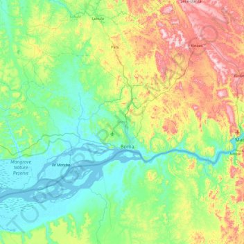
Name: Boma topographic map, elevation, terrain.
Location: Boma, Kongo Central, Democratic Republic of the Congo (-6.01170 12.61706 -5.51456 13.48130)
Average elevation: 160 m
Minimum elevation: -1 m
Maximum elevation: 578 m
Other topographic maps
Click on a map to view its topography, its elevation and its terrain.
Inga
Democratic Republic of the Congo > Kongo Central > Seke-Banza
Inga, Seke-Banza, Kongo Central, Democratic Republic of the Congo
Average elevation: 227 m
Kasangulu
Democratic Republic of the Congo > Kongo Central
Kasangulu, Kongo Central, Democratic Republic of the Congo
Average elevation: 479 m
Luozi
Democratic Republic of the Congo > Kongo Central > Luozi
Luozi, Kongo Central, Democratic Republic of the Congo
Average elevation: 202 m
Loango
Democratic Republic of the Congo > Kongo Central > Mbanza-Ngungu
Loango, Mbanza-Ngungu, Kongo Central, Democratic Republic of the Congo
Average elevation: 522 m
Lukula
Democratic Republic of the Congo > Kongo Central > Lukula
Lukula, Kongo Central, Democratic Republic of the Congo
Average elevation: 144 m
Chute Vampa
Democratic Republic of the Congo > Kongo Central > Songololo
Chute Vampa, Songololo, Kongo Central, Democratic Republic of the Congo
Average elevation: 409 m
Massif
Democratic Republic of the Congo > Kongo Central > Songololo
Massif, Songololo, Kongo Central, Democratic Republic of the Congo
Average elevation: 423 m
Matadi
Democratic Republic of the Congo > Kongo Central
Matadi, Kongo Central, Democratic Republic of the Congo
Average elevation: 219 m
Mont Amba
Democratic Republic of the Congo > Kongo Central
Mont Amba, Kongo Central, Democratic Republic of the Congo
Average elevation: 359 m