
Hendry County topographic map
Interactive map
Click on the map to display elevation.
About this map
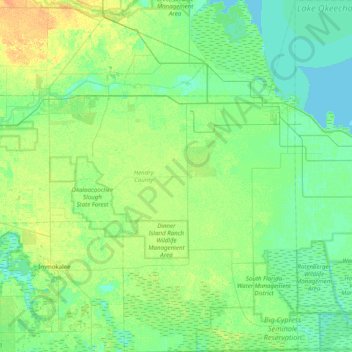
Name: Hendry County topographic map, elevation, terrain.
Location: Hendry County, Florida, USA (26.25312 -81.56630 26.95892 -80.87972)
Average elevation: 8 m
Minimum elevation: 1 m
Maximum elevation: 24 m
Other topographic maps
Click on a map to view its topography, its elevation and its terrain.
Cantonment
USA > Florida > Cantonment
Cantonment, Escambia County, Florida, 11142, USA
Average elevation: 38 m
Mountain Lake Station
USA > Florida > Mountain Lake Station
Mountain Lake Station, Polk County, Florida, 33877, USA
Average elevation: 47 m
Harbor Shores
USA > Florida > Harbor Shores
Harbor Shores, Lake County, Florida, 32735, USA
Average elevation: 23 m
The Villages
USA > Florida > The Villages
The Villages, Lake County, Florida, USA
Average elevation: 27 m
Deerfield Beach
USA > Florida > Deerfield Beach
Deerfield Beach, Broward County, Florida, USA
Average elevation: 5 m
Dawson Island
USA > Florida > Jacksonville
Dawson Island, Jacksonville, Duval County, Florida, USA
Average elevation: 2 m
St. Augustine
USA > Florida > St. Augustine
St. Augustine, St. Johns County, Florida, 32084, USA
Average elevation: 5 m
Dry Tortugas National Park
Dry Tortugas National Park, Monroe County, Florida, USA
Average elevation: 0 m