
Alibori Department topographic map
Interactive map
Click on the map to display elevation.
About this map
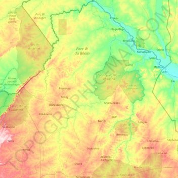
Name: Alibori Department topographic map, elevation, terrain.
Location: Alibori Department, Benin (10.52339 2.02188 12.40920 3.83881)
Average elevation: 263 m
Minimum elevation: 153 m
Maximum elevation: 506 m
Other topographic maps
Click on a map to view its topography, its elevation and its terrain.
Atlantique Department
Atlantique Department, Benin
Average elevation: 39 m
Africa Kparou
Benin > Borgou > Gounkparé > Africa Kparou
Africa Kparou, Gounkparé, Pèrèrè, Borgou, Benin
Average elevation: 348 m