
Champaign County topographic map
Interactive map
Click on the map to display elevation.
About this map
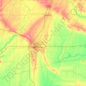
Name: Champaign County topographic map, elevation, terrain.
Location: Champaign County, Illinois, United States of America (39.87910 -88.46357 40.40068 -87.92882)
Average elevation: 217 m
Minimum elevation: 187 m
Maximum elevation: 260 m
The topography of Champaign County was formed by the Wisconsin Glacier about 20,000 years before the present. Lobes of ice from what is now Lake Michigan crossed the county, creating a deep pile of glacial soil, up to 300 feet thick, topped by numerous moraines forming small, flat watersheds with no outlets.
Other topographic maps
Click on a map to view its topography, its elevation and its terrain.
Deerfield
United States of America > Illinois > Deerfield
Deerfield, Illinois, United States of America
Average elevation: 204 m
Mount Vernon
United States of America > Illinois > Mount Vernon
Mount Vernon, Jefferson County, Illinois, 62864, United States of America
Average elevation: 147 m
Vergennes
United States of America > Illinois > Vergennes
Vergennes, Jackson County, Illinois, United States of America
Average elevation: 121 m
Woodford
United States of America > Illinois > Woodford
Woodford, Woodford County, Illinois, United States of America
Average elevation: 220 m
Wayne County
United States of America > Illinois
Wayne County, Illinois, United States of America
Average elevation: 133 m
Douglas County
United States of America > Illinois
Douglas County, Illinois, United States of America
Average elevation: 204 m
Adams County
United States of America > Illinois
Adams County, Illinois, United States of America
Average elevation: 196 m