
McDuffie County topographic map
Interactive map
Click on the map to display elevation.
About this map
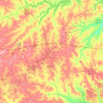
Name: McDuffie County topographic map, elevation, terrain.
Location: McDuffie County, Georgia, United States of America (33.31088 -82.64971 33.65999 -82.29433)
Average elevation: 136 m
Minimum elevation: 63 m
Maximum elevation: 191 m
Other topographic maps
Click on a map to view its topography, its elevation and its terrain.
Murray County
United States of America > Georgia
Murray County, Georgia, United States of America
Average elevation: 381 m
Sandy Springs
United States of America > Georgia > Sandy Springs
Sandy Springs, Fulton County, Georgia, United States of America
Average elevation: 301 m