
Howard County topographic map
Interactive map
Click on the map to display elevation.
About this map
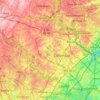
Name: Howard County topographic map, elevation, terrain.
Location: Howard County, Maryland, USA (39.10306 -77.18698 39.36954 -76.69636)
Average elevation: 128 m
Minimum elevation: 2 m
Maximum elevation: 266 m
Other topographic maps
Click on a map to view its topography, its elevation and its terrain.
Grahams Green Acres
USA > Maryland > Grahams Green Acres
Grahams Green Acres, Carroll County, Maryland, 21776, USA
Average elevation: 223 m