
Wadi Qattara Passage topographic map
Interactive map
Click on the map to display elevation.
About this map
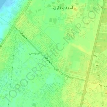
Name: Wadi Qattara Passage topographic map, elevation, terrain.
Location: Wadi Qattara Passage, Benghazi, 17016, Libya (32.03934 20.03534 32.05303 20.05693)
Average elevation: 11 m
Minimum elevation: -2 m
Maximum elevation: 16 m
Other topographic maps
Click on a map to view its topography, its elevation and its terrain.
Benghazi
The largest Ottoman architectural monument in Benghazi is the late 19th-century Ottoman palace in El-Berka; built during the rule of Rashid Pasha II. The front elevation was completed in 1895, whilst the side sections were added later during Italian rule. The white and green structure houses 360 rooms; and is…
Average elevation: 23 m