
Oviède topographic map
Interactive map
Click on the map to display elevation.
About this map
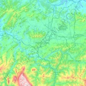
Name: Oviède topographic map, elevation, terrain.
Location: Oviède, Asturies, 33009, Espagne (43.20042 -6.00505 43.52042 -5.68505)
Average elevation: 344 m
Minimum elevation: 13 m
Maximum elevation: 1,704 m
Other topographic maps
Click on a map to view its topography, its elevation and its terrain.
Cobertoria
Espagne > Asturies > Oviède > La Rebollá
Cobertoria, La Rebollá, Oviède, Asturies, 33195, Espagne
Average elevation: 334 m