
Épinal topographic map
Interactive map
Click on the map to display elevation.
About this map
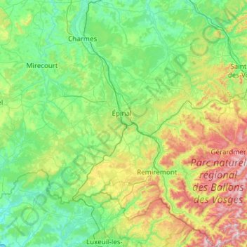
Name: Épinal topographic map, elevation, terrain.
Location: Épinal, Vosges, Grand Est, Metropolitan France, France (47.81369 6.10152 48.47305 7.01621)
Average elevation: 433 m
Minimum elevation: 213 m
Maximum elevation: 1,241 m
Other topographic maps
Click on a map to view its topography, its elevation and its terrain.
Col du Platzerwasel
France > Grand Est > Haut-Rhin > Mittlach
The Col du Platzerwasel (elevation 1,182 m (3,878 ft)) is a mountain pass situated in the Vosges Mountains in the Haut-Rhin department of France, between Sondernach and Le Markstein. It has been crossed occasionally during the Tour de France cycle race, including on Stage 10 of the 2014 race.
Average elevation: 1,024 m
La Trace
France > Grand Est > Haute-Marne > Roches-Bettaincourt > Bettaincourt-sur-Rognon
Average elevation: 271 m
Berges de la Birsig
France > Grand Est > Haut-Rhin > Leymen > Berges de la Birsig
Average elevation: 400 m
Quartier des Aviateurs
France > Grand Est > Bas-Rhin > Sélestat > Quartier des Aviateurs
Average elevation: 175 m