
Pierce County topographic map
Interactive map
Click on the map to display elevation.
About this map
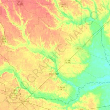
Name: Pierce County topographic map, elevation, terrain.
Location: Pierce County, Georgia, United States (31.20212 -82.42095 31.53070 -81.99209)
Average elevation: 37 m
Minimum elevation: 12 m
Maximum elevation: 61 m
Other topographic maps
Click on a map to view its topography, its elevation and its terrain.
Stone Mountain
United States > Georgia > DeKalb County
The park is owned by the state of Georgia. At its summit, the elevation is 1,686 feet (514 m) above sea level and 825 feet (251 m) above the surrounding area. Stone Mountain is well known for not only its geology, but also the enormous rock relief on its north face, the largest bas-relief artwork in the world.…
Average elevation: 299 m