
Coulsdon topographic map
Click on the map to display elevation.
Coulsdon
1804. The Surrey Iron Railway was enhanced by the "Coulsdon Merstham & Godstone Railway". These were horsedrawn railways which carried quarried materials and crops from Coulsdon and Merstham, and returned with fuel, metals and other materials. To maintain a regular elevation at Coulsdon required large changes in direction and the construction of 20 ft embankments and a road bridge. Remnants of the 1805 railway embankment are still evident. The railway closed in 1838 due to underuse. A bridge over the Chipstead Valley road was demolished as dangerous in 1854.
About this map
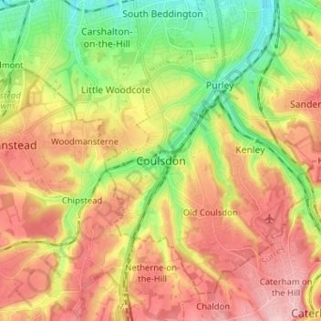
Name: Coulsdon topographic map, elevation, terrain.
Location: Coulsdon, Greater London, England, CR5 2NF, United Kingdom (51.27997 -0.17935 51.35997 -0.09935)
Average elevation: 125 m
Minimum elevation: 50 m
Maximum elevation: 197 m
Other topographic maps
Click on a map to view its topography, its elevation and its terrain.
London Borough of Richmond upon Thames
United Kingdom > England > Greater London
Average elevation: 18 m
Norwood Grove
United Kingdom > England > Greater London
After Anderson died, ownership passed to the Nettlefold family and subsequently to Frederick Nettlefold the brother of Joseph Nettlefold and a member of the family that founded the Nettlefolds Ltd. engineering firm which later became GKN. Nettlefold is commemorated, as a result of his charitable works, by a…
Average elevation: 58 m
Pymmes Brook
United Kingdom > England > Greater London
Prior to the Anglian glaciation, a "proto-Mole-Wey" river was flowing northwards from the Weald and North Downs, through the "Finchley depression" and Palmers Green, to join the proto-Thames somewhere around Hoddesdon, at what is today an altitude of around 60 metres. It was this river which, during the course…
Average elevation: 41 m