
Krakow topographic map
Interactive map
Click on the map to display elevation.
About this map
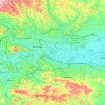
Name: Krakow topographic map, elevation, terrain.
Location: Krakow, Lesser Poland Voivodeship, Poland (49.96767 19.79224 50.12613 20.21735)
Average elevation: 258 m
Minimum elevation: 187 m
Maximum elevation: 457 m
Other topographic maps
Click on a map to view its topography, its elevation and its terrain.
Torba
Poland > Lesser Poland Voivodeship > Kraków County > Szklary > Góra
Torba, Góra, Szklary, gmina Jerzmanowice-Przeginia, Kraków County, Lesser Poland Voivodeship, Poland
Average elevation: 423 m
Olkusz
Poland > Lesser Poland Voivodeship > Olkusz County > Olkusz
Olkusz, gmina Olkusz, Olkusz County, Lesser Poland Voivodeship, Poland
Average elevation: 367 m
Zakopane
Poland > Lesser Poland Voivodeship > Tatra County > Zakopane
Zakopane, Tatra County, Lesser Poland Voivodeship, 34-500, Poland
Average elevation: 974 m
Wieliczka
Poland > Lesser Poland Voivodeship > Wieliczka
Wieliczka, gmina Wieliczka, powiat wielicki, Lesser Poland Voivodeship, 32-020, Poland
Average elevation: 270 m
Nowy Targ
Poland > Lesser Poland Voivodeship > Nowy Targ County
Nowy Targ, Nowy Targ County, Lesser Poland Voivodeship, Poland
Average elevation: 676 m