
Districts of Republican Subordination topographic map
Interactive map
Click on the map to display elevation.
About this map
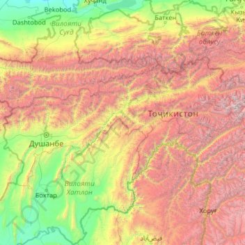
Name: Districts of Republican Subordination topographic map, elevation, terrain.
Location: Districts of Republican Subordination, Tajikistan (37.85172 68.05669 39.61149 72.23204)
Average elevation: 2,261 m
Minimum elevation: 278 m
Maximum elevation: 7,056 m
Other topographic maps
Click on a map to view its topography, its elevation and its terrain.
Gorno-Badakhshan Autonomous Region
Gorno-Badakhshan Autonomous Region, Tajikistan
Average elevation: 3,967 m
Кызылсу
Кызылсу, Temurmalik District, Khatlon Region, 735330, Tajikistan
Average elevation: 940 m
Fedchenko Glacier
Tajikistan > Gorno-Badakhshan Autonomous Region
Fedchenko Glacier, Murghob District, Gorno-Badakhshan Autonomous Region, Tajikistan
Average elevation: 4,603 m