
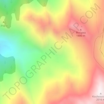
Pindus topographic map
Interactive map
Click on the map to display elevation.
About this map
Name: Pindus topographic map, elevation, terrain.
Average elevation: 1,510 m
Minimum elevation: 942 m
Maximum elevation: 2,013 m
Other topographic maps
Click on a map to view its topography, its elevation and its terrain.
Dytiki Soufla
Greece > Thessaly - Central Greece
Dytiki Soufla, Δήμος Δωρίδος, Regional Unit of Phocis, Region of Central Greece, Thessaly - Central Greece, 33052, Greece
Average elevation: 1,893 m
Lafina
Greece > Thessaly - Central Greece > Lafina
Lafina, Pyli Municipality, Regional Unit of Trikala, Region of Thessaly, Thessaly - Central Greece, 42037, Greece
Average elevation: 926 m
Dytiki Frangista
Greece > Thessaly - Central Greece > Dytiki Frangista
Dytiki Frangista, Δήμος Αγράφων, Regional Unit of Evrytania, Region of Central Greece, Thessaly - Central Greece, 36071, Greece
Average elevation: 760 m