
Hood River County topographic map
Interactive map
Click on the map to display elevation.
About this map
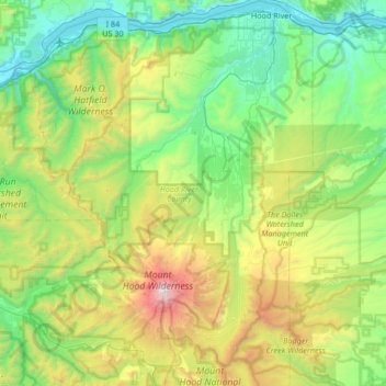
Name: Hood River County topographic map, elevation, terrain.
Location: Hood River County, Oregon, United States (45.25773 -121.92227 45.72655 -121.44058)
Average elevation: 860 m
Minimum elevation: 2 m
Maximum elevation: 3,388 m
Hood River County is 533 square miles (1,380 km2), of which 522 square miles (1,350 km2) is land and 11 square miles (28 km2) (2.1%) is water. It is the second-smallest county in Oregon by area. Elevation ranges from 60 feet (18 m) above sea level at Cascade Locks in the northwest to 11,235 feet (3,424 m) at the summit of Mt. Hood, the highest point in Oregon.
Other topographic maps
Click on a map to view its topography, its elevation and its terrain.
Beaverton
United States > Oregon > Washington County
Beaverton, Washington County, Oregon, United States
Average elevation: 106 m
Lazarus Island
United States > Oregon > Tillamook County > Wheeler Heights
Lazarus Island, Wheeler Heights, Tillamook County, Oregon, United States
Average elevation: 43 m
Clackamas County
Clackamas County, Oregon, United States
Average elevation: 660 m
Deschutes County
Deschutes County, Oregon, United States
Average elevation: 1,324 m