
Kazungula topographic map
Interactive map
Click on the map to display elevation.
About this map
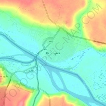
Name: Kazungula topographic map, elevation, terrain.
Location: Kazungula, Kazungula District, Southern Province, Zambia (-17.82779 25.23602 -17.74779 25.31602)
Average elevation: 944 m
Minimum elevation: 920 m
Maximum elevation: 990 m
Other topographic maps
Click on a map to view its topography, its elevation and its terrain.
Kafue National Park
Kafue National Park, Southern Province, Zambia
Average elevation: 1,129 m
Livingstone
Zambia > Southern Province > Livingstone
Livingstone, Southern Province, Zambia
Average elevation: 961 m
Victoria Falls
Zambia > Southern Province > Livingstone
Victoria Falls, Livingstone, Southern Province, Zambia
Average elevation: 877 m