
Zaozhuang City topographic map
Interactive map
Click on the map to display elevation.
About this map
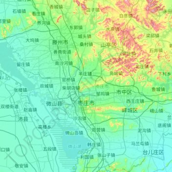
Name: Zaozhuang City topographic map, elevation, terrain.
Location: Zaozhuang City, Shandong, China (34.46237 116.80917 35.32532 117.83048)
Average elevation: 97 m
Minimum elevation: 22 m
Maximum elevation: 633 m
Zaozhuang City is located in the southern part of the low hills of Luzhong, and belongs to the Huanghuai Plain. The terrain is high in the north, low in the south, low in the east and low in the west, and it is inclined to the northeast to the southwest. The mountain in the northern Shanting District is 620 meters above sea level, which is the highest point in the city. The mountains, such as the Lianqing Mountain and the Baoji Mountain, are more than 500 meters above sea level, and the mountains are undulating and swaying in the north of the city. Holding 580 meters above sea level, it is called "the first of the seventy-two scorpions." The western lakeside and the coastal zone have the lowest terrain and flat ground, with an altitude of 30–40 meters and a minimum elevation of 24.5 meters. The topography and landforms in the territory are relatively complex, forming many types of landforms such as low mountains, hills, piedmont plains, floodplains, and lakes along the lake. The hills account for 54.6% of the total area, the plains account for 26.6% of the total area, and the depression accounts for 18.8% of the total area.