
Humboldt County topographic map
Interactive map
Click on the map to display elevation.
Humboldt County
The coastal zone of the county experiences very wet, cool winters and dry, mild foggy summers. In the winter, temperatures range from highs of 40–59 °F (4–15 °C) to lows of 32–49 °F (0–9 °C). Coastal summers are cool to mild, with average highs of 60–69 °F (16–21 °C) and frequent fogs. Coastal summer temperatures range from highs of 64–70 °F (18–21 °C) to lows of 46–55 °F (8–13 °C). In the populated areas and cities near the coast, the highest temperatures tend to occur at locations just a few miles inland from Eureka and Arcata, in towns like Fortuna, Rio Dell, and smaller unincorporated communities located somewhat further away from Humboldt Bay. In these locations summer highs are 70–75 °F (21–24 °C). The coastal zone experiences a number of frosty nights in winter and early spring, though snowfall and hard freezes are rare. Coastal winters are cool and wet. Winter rainstorms are frequent, with averages from 30 to 100 inches (760 to 2,500 mm) a year, depending upon elevation.
About this map
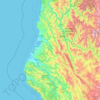
Name: Humboldt County topographic map, elevation, terrain.
Location: Humboldt County, California, United States (40.00139 -124.48200 41.46584 -123.40575)
Average elevation: 540 m
Minimum elevation: -3 m
Maximum elevation: 2,624 m
Other topographic maps
Click on a map to view its topography, its elevation and its terrain.