
Sungai Air Putih topographic map
Interactive map
Click on the map to display elevation.
About this map
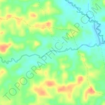
Name: Sungai Air Putih topographic map, elevation, terrain.
Location: Sungai Air Putih, Jambi, Indonesia (-1.46387 103.33398 -1.45662 103.36845)
Average elevation: 31 m
Minimum elevation: 12 m
Maximum elevation: 57 m
Other topographic maps
Click on a map to view its topography, its elevation and its terrain.
Mount Kerinci
Indonesia > Jambi > Sungai Penuh
Mount Kerinci, Sungai Penuh, Kecamatan Serai Serumpun, Jambi, Indonesia
Average elevation: 3,229 m
Desa Seringat
Indonesia > Jambi > Desa Seringat
Desa Seringat, Kecamatan Sumay, Jambi, Indonesia
Average elevation: 175 m