
Strömstad topographic map
Interactive map
Click on the map to display elevation.
About this map
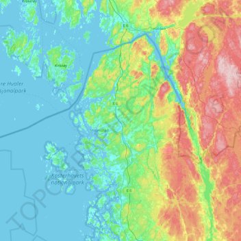
Name: Strömstad topographic map, elevation, terrain.
Location: Strömstad, Provincia de Västra Götaland, Götaland, Suecia (58.76096 10.59310 59.11498 11.46460)
Average elevation: 45 m
Minimum elevation: -1 m
Maximum elevation: 250 m
Other topographic maps
Click on a map to view its topography, its elevation and its terrain.
Grude distrikt
Suecia > Provincia de Västra Götaland > Ljung
Grude distrikt, Ljung, Herrljunga, Provincia de Västra Götaland, Götaland, 524 41, Suecia
Average elevation: 167 m
Hisingen
Suecia > Provincia de Västra Götaland > Gotemburgo
Hisingen, Gotemburgo, Göteborg, Provincia de Västra Götaland, Götaland, Suecia
Average elevation: 31 m
Västra Hisingen
Suecia > Provincia de Västra Götaland > Skra Bro
Västra Hisingen, Skra Bro, Göteborg, Provincia de Västra Götaland, Götaland, 423 59, Suecia
Average elevation: 15 m
Tjörn
Suecia > Provincia de Västra Götaland
Tjörn, Provincia de Västra Götaland, Götaland, Suecia
Average elevation: 6 m
Orusts kommun
Suecia > Provincia de Västra Götaland > Orusts kommun
Orusts kommun, Orust kommun, Provincia de Västra Götaland, Götaland, 473 31, Suecia
Average elevation: 77 m