
Hørsholm Municipality topographic map
Interactive map
Click on the map to display elevation.
About this map
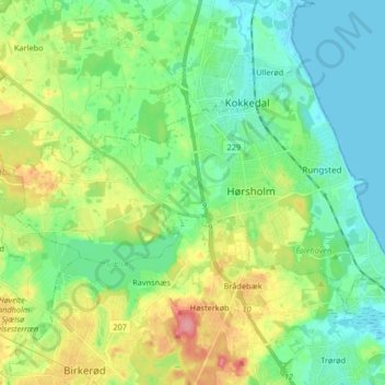
Name: Hørsholm Municipality topographic map, elevation, terrain.
Location: Hørsholm Municipality, Capital Region of Denmark, Denmark (55.85243 12.39754 55.91336 12.56208)
Average elevation: 28 m
Minimum elevation: -1 m
Maximum elevation: 89 m
Other topographic maps
Click on a map to view its topography, its elevation and its terrain.
Copenhagen Municipality
Denmark > Capital Region of Denmark
Copenhagen Municipality, Capital Region of Denmark, Denmark
Average elevation: 5 m
Copenhagen
Denmark > Capital Region of Denmark
Copenhagen, Copenhagen Municipality, Capital Region of Denmark, 1357, Denmark
Average elevation: 9 m
Viberup
Denmark > Capital Region of Denmark > Viberup
Viberup, Tårnby Kommune, Capital Region of Denmark, 2770, Denmark
Average elevation: 1 m
Frederiksberg Municipality
Denmark > Capital Region of Denmark
Frederiksberg Municipality, Capital Region of Denmark, Denmark
Average elevation: 15 m
Bornholm
Denmark > Capital Region of Denmark
Bornholm, Capital Region of Denmark, Denmark
Average elevation: 33 m
Tisvilde
Denmark > Capital Region of Denmark > Tisvilde
Tisvilde, Gribskov Municipality, Capital Region of Denmark, 3220, Denmark
Average elevation: 18 m